
An Island in a Lake on an Island in a Lake on an Island: The Strange Case of Taal's Vulcan Point
In Batangas, a volcano sits in a lake, a lake sits in that volcano, and a tiny rock sits in that lake. Here is how this geographic tongue-twister formed, what the 2020 eruption did to it, and why it is not quite the world record it is often called.
In one paragraph
Vulcan Point is a small rocky islet inside the Main Crater Lake of Taal Volcano. That crater lake sits on Volcano Island, which rises from Taal Lake, which lies on the island of Luzon in the Philippines. That makes Vulcan Point an island in a lake on an island in a lake on an island, a rare arrangement geographers call a third-order island. For years it was described as the largest of its kind, but a bigger example has since been identified in the Canadian Arctic.
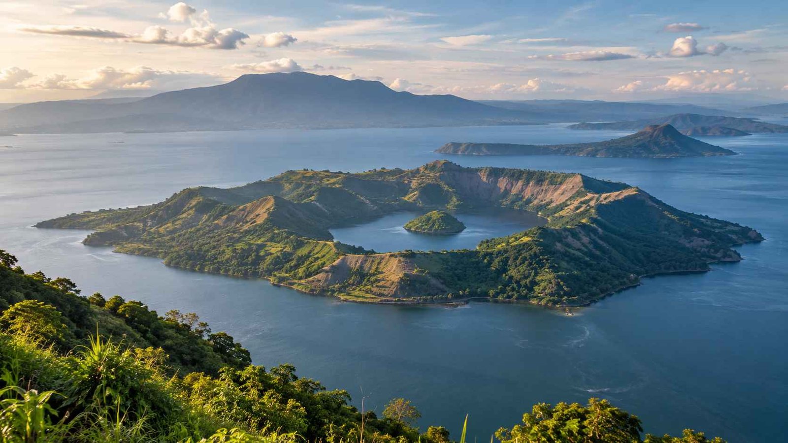
Layer 1 · Island in the sea
Luzon
The largest island of the Philippines and home to Metro Manila. Its southern province of Batangas holds the next layer.
Unpacking the tongue-twister
Say it slowly: an island, in a lake, on an island, in a lake, on an island. It sounds like a riddle, but it is an accurate street address for one small rock in Batangas.
The trick is to read the phrase from the inside out. Each "in" is a piece of land surrounded by water, and each "on" is a body of water sitting on land. Taal stacks these layers five deep, which is rare anywhere on Earth and even rarer for a place that sits beside a major metropolitan area.
- IslandLuzon
The Philippines' largest island, surrounded by the sea.
- Lake on an islandTaal Lake
A huge water-filled caldera in Batangas, the country's third-largest lake.
- Island in a lake on an islandVolcano Island
The active heart of Taal Volcano, rising near the center of Taal Lake.
- Lake on an island in a lake on an islandMain Crater Lake
The water that filled the volcano's main crater after the 1911 eruption.
- Island in a lake on an island in a lake on an islandVulcan Point
A small rocky islet poking out of the crater lake. The innermost layer.
Taal Lake: a volcano that swallowed its own top
Taal Lake looks calm and postcard-pretty from the ridge at Tagaytay, but the basin it fills was carved by violence. It occupies a caldera, the collapsed hollow left after a volcano empties its underground magma chamber in enormous eruptions. Geologists date the eruptions that built this caldera to many thousands of years ago, long before written records.
For much of its history the lake was not a lake at all, at least not a freshwater one. It was connected to the sea through Balayan Bay, and its water was salty. That changed with the 1754 eruption, the most powerful in Taal's recorded history. Volcanic debris choked the Pansipit River channel that drained the lake toward the bay, the water level rose, and over time rain gradually turned the basin into fresh water.
That slow change left behind some remarkable residents. Taal Lake is home to the tawilis (Sardinella tawilis), a sardine that lives only in fresh water and only in this lake. It also shelters a rare sea snake, Hydrophis semperi, which has adapted to life in fresh water. Both are reminders that the lake was once part of the ocean.
Volcano Island: small, restless, and off-limits
Rising near the center of the lake is Volcano Island, the part most people picture when they hear "Taal Volcano." It is small for a volcano, yet it is one of the most active in the Philippines, with dozens of recorded eruptions since the Spanish colonial era. Scientists have mapped many separate craters on the island, evidence of eruptions that broke through in different spots over the centuries.
Its deadliest recorded eruption came in January 1911, when official counts reported more than a thousand deaths. That eruption also reshaped the summit, setting the stage for the next two layers of our nesting doll.
Because of its danger and its closeness to millions of people in Batangas, Cavite and Metro Manila, Taal was named one of the Decade Volcanoes, a short international list of volcanoes singled out for focused study. The Philippine Institute of Volcanology and Seismology (PHIVOLCS) treats the entire island as a Permanent Danger Zone, where permanent settlement is prohibited.
Main Crater Lake: a lake born from an eruption
The crater at the top of Volcano Island has not always held a single lake. Accounts from before 1911 describe separate pools within it, often called the Green Lake and the Yellow Lake, with a smaller red-tinted pool that appeared in rainy seasons.
The 1911 eruption blasted the crater into a new shape. Afterward, water collected into one larger basin, which eventually became the Main Crater Lake. Fed largely by rain and heated from below, its water has often been strongly acidic and mineral-rich, and its color has shifted between shades of green and yellow depending on volcanic activity.
Every layer of this riddle exists because of an eruption. Taal did not just build its nested islands; it is still rearranging them.
Vulcan Point: the rock at the center
And then, inside the crater lake, a small dark islet breaks the surface. That is Vulcan Point. Sources describe it as a remnant of the volcano's older crater floor, the top of a small cone that was left standing when water filled the crater after 1911.
Before 2020, photos showed Vulcan Point with a fringe of vegetation, a surprisingly green dot in an otherwise harsh volcanic setting. It is only a sliver of rock, but its position makes it famous. It is the innermost layer of a five-part sequence, and it gives Taal one of the most unusual geographic descriptions in the world.
Vulcan Point is usually called a third-order island: an island in a lake on an island in a lake on an island. Some lists count the layers differently (for example, by including the surrounding sea), so you may also see it listed under a different "order." The physical arrangement is the same either way.
Was it really the world's largest?
For years, Vulcan Point was widely described online as the world's largest island in a lake on an island in a lake on an island. That claim no longer holds. In 2007, island geographer Josh Calder, studying satellite imagery, identified an unnamed islet on Victoria Island in Canada's Arctic that fits the same pattern and is larger. It is now generally regarded as the largest known third-order island.
That doesn't make Vulcan Point less special. The Canadian example sits in a remote tundra landscape of countless small lakes, while Vulcan Point owes its existence to an active volcano a short drive from one of Asia's biggest cities. Here is how the nesting record-holders compare:
| Type | Notable example | Where |
|---|---|---|
| Island in a lake | Many examples worldwide | Every continent with lakes |
| Island in a lake on an island | Samosir, often cited as the largest | Lake Toba, Sumatra, Indonesia |
| Island in a lake on an island in a lake | Treasure Island, often cited as the largest natural one | Lake Mindemoya, Manitoulin Island, Lake Huron, Canada |
| Third-order island | Unnamed islet, generally regarded as the largest | Victoria Island, Nunavut, Canada |
| Third-order island | Vulcan Point, the most famous volcanic example | Taal, Batangas, Philippines |
The day the crater lake vanished
On January 12, 2020, Taal erupted after decades of relative quiet. A towering column of steam and ash rose over Batangas, ash fell across nearby provinces and Metro Manila, PHIVOLCS raised the alert to Level 4, and large-scale evacuations followed. The eruption was linked to 39 deaths, many of them indirect.
In the days that followed, satellite images revealed something startling: the Main Crater Lake had largely disappeared. Heat from below and new cracks in the crater floor drove off most of the water, leaving only small pockets behind. For a while, Vulcan Point was no longer an island in a lake. It was simply a rock on a dry crater floor, and the famous five-layer riddle was briefly broken.
Vulcan Point rises from a green-yellow crater lake, with vegetation on its slopes.
The eruption boils and drains away most of the crater lake. The innermost layer loses its water.
Rainfall, including from later typhoons, refills the crater, and Vulcan Point becomes an island again.
Vulcan Point itself survived the eruption, though its vegetation did not fare as well. As rain returned, the crater gradually filled again and the nesting pattern was restored. Taal has continued to show periodic unrest since then, so the crater lake's size, color and chemistry remain changeable, a reminder that this geographic curiosity sits on a living volcano.
Can you go and see it?
Not up close. Because Volcano Island is a Permanent Danger Zone, travelers should not plan to land on the island or hike to the crater rim, regardless of what older travel blogs may describe. Access rules depend on the volcano's current alert level, which PHIVOLCS updates as conditions change.
The safest way to appreciate the layers is from a distance. The Tagaytay Ridge in Cavite overlooks Taal Lake and Volcano Island, offering a wide view of the outer layers of the riddle. From there, you are looking across the second and third layers of the riddle, with Vulcan Point hidden in the crater beyond.
Before traveling anywhere near Taal, check the latest bulletin from PHIVOLCS and follow advice from local authorities. Volcanic gas, sudden steam explosions and ashfall can occur with little warning.
More than a trivia question
Vulcan Point is a fun fact, but the layers around it tell a serious scientific story. The caldera shows how massive eruptions can collapse a landscape. The lake's journey from salt water to fresh water shows how one eruption can rewrite an ecosystem and give rise to species found nowhere else. And the crater lake's disappearance in 2020 gave scientists a vivid, real-time look at how quickly a volcano can reshape its own summit.
For Filipinos, Taal is also a place of memory, livelihood and resilience. Fishing families, farmers and tourism workers around the lake have rebuilt more than once. Behind the tongue-twister is a community that has learned to live beside one of the most unusual and unpredictable volcanoes on Earth.
True or false? Test your layers
Four statements. Tap True or False for each one.
Taal Lake was once connected to the sea and had salty water.
True. The lake was linked to Balayan Bay until the 1754 eruption blocked its outlet, and it slowly became fresh water.
Vulcan Point is the largest known island in a lake on an island in a lake on an island.
False. A larger example on Victoria Island, Canada, was identified in 2007 and is generally regarded as the largest.
After the January 2020 eruption, the Main Crater Lake largely dried up.
True. Satellite images showed most of the water was gone. Rain later refilled the crater.
Visitors can freely camp on Volcano Island today.
False. PHIVOLCS treats the whole island as a Permanent Danger Zone where permanent settlement is prohibited.
Frequently asked questions
Where exactly is Vulcan Point?
It is inside the Main Crater Lake on Volcano Island, at the center of Taal Lake in Batangas province, on Luzon in the Philippines, about 50 km south of Manila.
What is a third-order island?
It is an island in a lake on an island in a lake on an island. Vulcan Point is the best-known volcanic example of this rare arrangement.
Is Vulcan Point still there after the 2020 eruption?
Yes. The crater lake around it largely dried up after the January 12, 2020 eruption, but Vulcan Point survived, and rainfall later refilled the lake. Conditions in the crater can change with volcanic activity.
Is Vulcan Point the largest island of its kind?
No. It was often described that way, but a larger example on Victoria Island in Canada, identified in 2007, is generally regarded as the largest known third-order island.
Can tourists visit Vulcan Point?
Not up close. Volcano Island is a Permanent Danger Zone. The safest views of Taal Lake and Volcano Island are from viewpoints such as the Tagaytay Ridge, and travelers should always check current PHIVOLCS advisories.
Why is Taal Lake fresh water if it was once part of the sea?
The 1754 eruption blocked the river channel connecting the lake to Balayan Bay. The water level rose, and over many years rainwater gradually replaced the salt water.